
Flood 2016
Flood Forecasting for Central
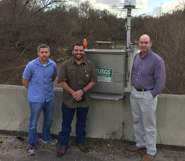 Pictured from left to right: Todd Baumann, Jaysson Funkhouser, John Storm, key USGS personnel in Central’s Flood Inundation Mapping Project, in Central to inspect river guages like this one on the Comite River
On August 12, the day before last August’s flooding, authorities warned that both the Amite and Comite Rivers would crest well above record levels, but no one fully understood what that meant to the residents of Central. Thanks to flood inundation computer modeling available through the U.S. Geological Survey, a Federal agency, by 2018 Central will have a tool to forecast the flooding that would be associated with the rising Amite and Comite Rivers. This will be the first such project in Louisiana.
Like most Central residents, local logistics business owner and Central Speaks editor Dave Freneaux spent the weeks and months after the flooding gutting the homes of family members. He explains that one question stayed on his mind each day as he and family members tried to salvage precious photos and heirlooms. “With all of the technology available to us, why didn’t we know?”
Freneaux began searching for that answer, and found it in the form of a computerized flood inundation map for the city of Hattiesburg Mississippi. The U.S.G.S. had modeled the effect of flooding of the Leaf River, resulting in an interactive web-based tool that anyone can use to predict the water level anywhere in Hattiesburg simply by knowing where the Leaf River will crest.
The search for a way to provide this inundation modeling for Central led to Jaysson Funkhouser of the U.S.G.S. Within weeks the U.S.G.S. came to Central where Council Member Jason Ellis responded to Freneaux’s invitation to Central’s Mayor and Council to meet and discuss the project. Ellis, a Professional Engineer, saw the value in the project and brought it to the City Council where the funding of $300,000 over two years was approved. The project should be completed and ready for use by October of 2018.
The most important benefit of this advanced modeling will be to keep both citizens and rescuers out of harm’s way by evacuating likely flood areas before the waters rise and people become trapped. The value of this tool to first responders is significant, allowing them to give advanced warning and evacuate at-risk neighborhoods. Then, if rescue operations are required, the inundation mapping will indicate routes still open to reach areas of the city.
This mapping tool will also help to alleviate the fears that now accompany each significant rain event in Central. Anyone with internet access will be able to go to Central’s mapping page and move two sliders on the map to the expected crests of the Amite and Comite Rivers. The resulting flood map will show the approximate water level at any home in Central.
Freneaux added, “The brave people of Central’s ‘Cajun Navy’ were invaluable in protecting lives, but I hope this mapping tool means that Central never again needs to launch such a rescue effort. No one could stop these two rivers, but with proper preparation lives will not be put at risk, thousands of vehicles will not have to be replaced at great cost, and irreplaceable family possessions will not be lost.”


0 comments