
Gov't
Beaver Bayou Flood Map Changes Approved
Expected to Be Effective July 15, 2016
City of Central Press Release
Photo by Expressions Photography
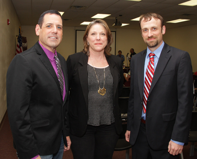 Pictured: Former Council Member Aaron Moak, Central citizen Kathi Cowen, and current Council Member Jason Ellis have each put in many hours of work to make the Beaver Bayou flood study a success. Not pictured: David Barrow, former Central CAO, worked for years with FEMA to get the study approved.
The City of Central is pleased to announce FEMA approval for the city funded project to update and revise FEMA flood elevations along portions of the Beaver Bayou watershed. This request was processed by FEMA as a Letter of Map Revision (LOMR). The project which began in 2012 took nearly four years to gain final approval which was received in a letter to Mayor Shelton dated March 2, 2016 from FEMA. A copy of that letter and the complete LOMR document which includes revised flood map panels and flood profiles for the studied areas along Beaver Bayou can be viewed by following the instructions below. These documents will be available online upon final acceptance at the FEMA Maps Service Center website and through the websites listed below:
www.centralgov.com – maps available
https://msc.fema.gov/portal – July 2016
http://maps.lsuagcenter.com/floodmaps/?FIPS=22051 – July 2016
City of Central Flood Insurance rates along the studied areas of the Beaver Bayou watershed are currently based on the 2008 and 2012 effective maps for the following map panels:
Map Panel No.: 22033CD185F
Date: June 19, 2012
Map Panel No.: 22033CD195F
Date: June 19, 2012
Map Panel No.: 22033CD205E
Date: May 2, 2008
Map Panel No.: 22033CD215E
Date: May 2, 2008
Map Panel No.: 22033CD260E
Date: May 2, 2008
The LOMR updated maps demonstrate a reduced flood risk for many areas within the Beaver Bayou Watershed due to the use of best available data including ground elevations, and more current hydrologic and hydraulic analysis completed by the cities consultant for the study Gulf Engineers & Consultants (GEC).
The following is a comparison from the existing and proposed flood risk areas:
Greater than 1,216 parcels decrease in the Base Flood Elevation – creating the potential for Flood Insurance Rate Savings when a property is rated based on risk.
Greater than 2,380 parcels have a zone change from AE (high risk) to X (reduced risk).
These updated LOMR maps still have some remaining steps prior to becoming effective. THE MAPS ARE NOT EFFECTIVE YET.
1. FEMA will publish a notice of changes in the Federal Register. This information will also be published in the Advocate on or around March 10, 2016 and March 17, 2016 and through FEMA’s Flood Hazard Mapping Website at https://www.floodmaps.fema.gov/fhm/bfe_status/bfe_main.asp
2. Within 90 days of the second publication in the local newspaper, a citizen may request that FEMA reconsiders this determination. Any request for reconsideration must be based on scientific or technical data.
3. The LOMR Maps will become effective only after the 90 day appeal period has elapsed and FEMA has resolved any appeals that are received during the appeal period. Until the LOMR is effective, the revised flood hazard information presented in the LOMR Maps may be changed.
The City of Central anticipates the completion of these steps and for the LOMR maps to become effective on or around July 15, 2016. Citizens are encouraged to view the updated maps at the links listed above or attend the meeting below to view the maps and ask general questions about flood risk with employees from the City of Central City Services Contractor IBTS Floodplain Management department and the City of Central.
CENTRAL COMMUNITY ALLIANCE MEETING – 16252 Wax Rd. (DEMCO) – Tuesday, March 15, 2016, 7:00 p.m. to 8:30 p.m.
The City of Central will mail individual notices of changes after the appeal period is ended and final verification of the effective date with FEMA is released. The City of Central will send by mail to each individual property owner affected by the LOMR, based on tax record address, notice of the effective changes and instructions on how property owners may be able to cancel or change their flood insurance rates. For more information on how this LOMR may affect cancellation of
your policy or refunds, please view the Q&A portion of the full press release document on the City of Central website, www.centralgov.com.
Please consider that FEMA recommends all property owners carry flood insurance and that your property may be eligible to continue coverage at a reduced rate. Assistance with any questions you may have regarding this subject can be obtained by contacting your flood insurance agent or at www.floodsmart.gov.
Detailed individual property inquiries regarding flood zones can be made in person to:
Natalia Gustafson, E.I., C.F.M.
Floodplain Management
Central Municipal Services
6703 Sullivan Road
Central, LA 70739
P: (225) 262-5000
F: (225) 262-5001
natalia.gustafson@central-la.gov


0 comments